Glenburgh South
Overview
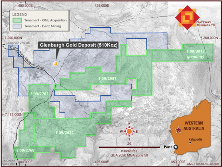
GML entered into a binding agreement with several parties to acquire an 80% interest in the Glenburgh South Project, located in the Gascoyne region of Western Australia. The project covers approximately 871 square kilometres of highly prospective tenure, situated within 10 kilometres of Benz Mining Corp’s 510 koz Glenburgh Gold Project.
This acquisition provides GML with exposure to a proven gold-bearing corridor within a rapidly emerging exploration district, complementing the Company’s existing Yandal and Horse Well assets and expanding its portfolio into another underexplored but geologically fertile region of Western Australia.
Geology
The project area is a part of the Gascoyne Complex, which has been formed during four orogenic events: Glenburgh Orogeny (2005-1960Ma), Capricorn Orogeny (1835-1780 Ma), Mangaroon Orogeny (1690-1620 Ma), and the Edmundian Orogeny (c. 900 Ma).
The project underlies the Glenburgh Orogeny whose rocks make up most of the Glenburgh Terrain making the southern part of the Gascoyne Complex abuts the Archaean granite complexes.
The Glenburgh Orogeny units mostly are from the Proterozoic Dalgaringa Supersuite. The lithology types include a range of metamorphosed amphibolite, tonalite, and granite, granodiorite, diorite, and monzogranite. The emplacement of the Dalgaringa Supersuite syn-metamorphic noted as being highly metamorphosed. Most of these are noted as migmatites or gneiss. Minor dolerite dykes occur after the Proterozoic.
Structures in the region typically trend in a northeast-southwest direction which is the primary structure and are crosscut by near-north or north-northeast faults. Crosscutting faults have an obvious displacement in certain areas. The existing faults can host quartz veins. Synforms have also been noted trending in a similar direction to the primary faults. Foliations and lineations subparallel orientations with adjacent faults.
A significant portion of the project has outcropping basement rocks and is covered by colluvium units of rock and quartz fragments mixed with sand and silt.
Exploration
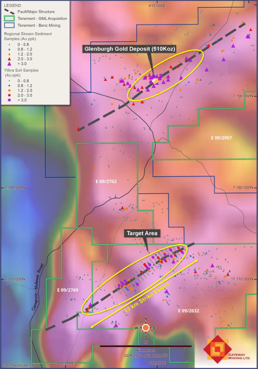
Historic exploration by Normandy Mining in 1994–1995 confirmed the gold potential of the Glenburgh South Project area, identifying a series of significant gold anomalies from regional stream sediment sampling. The samples returned gold values of up to 6.6 ppb Au, consistent with grades obtained from comparable stream sediment programs conducted across the nearby 510 koz Glenburgh Gold Deposit.
These results demonstrate that the Glenburgh South tenure lies within the same mineralised corridor as Benz Mining Corp’s Glenburgh Project, highlighting the strong geochemical and structural continuity between the two systems. The identification of multiple gold anomalies across Glenburgh South provides a robust foundation for GML’s planned first-pass surface geochemistry and reconnaissance mapping programs, aimed at refining targets for initial drilling.
One zone of gold anomalism identified on tenement E09/2632 was followed up with a closer-spaced soil sampling program at 400 metre × 200 metre spacings. In conjunction with this work, regional ground gravity data were reprocessed, and the combined datasets delineated a 13-kilometre-long surface gold anomaly. Importantly, this anomaly is positioned along a major regional structure identical to that which hosts the 510 koz Glenburgh Gold Deposit, underscoring the strong structural continuity and significant exploration potential across the Glenburgh South Project.